from HellsBelle@sh.itjust.works to world@lemmy.world on 10 Apr 16:47
https://sh.itjust.works/post/58296443
Access to open source visuals of the current Iran conflict, which has spread to many parts of the Middle East, continues to be sporadic. Videos and photos from within Iran trickle out on social media as the Iranian internet blackout hinders the flow of digital communication.
In past conflicts, satellite imagery has provided a vital overview of potential damage to both military and civilian infrastructure, especially when there are digital black spots or obstacles to on-the-ground reporting. But imagery from commercial providers is becoming increasingly restricted, leaving even those who have access to the most expensive imagery in the dark.
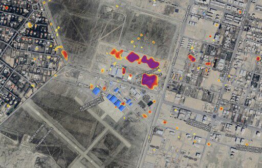
Shortly after the war in Gaza began in 2023, Bellingcat introduced a free tool authored by University College London lecturer and Bellingcat contributor, Ollie Ballinger, that was able to estimate the number of damaged buildings in a given area. This helped monitor and map the scale of destruction across the territory as Israel’s military operation progressed.
Bellingcat is now introducing an updated version of the open source tool — called the Iran Conflict Damage Proxy Map — focused on destruction in Iran and the wider Gulf region.
It can be accessed here.
#world
threaded - newest